As usual, I had been glued to the weather reports for the days leading up to this lesson and, as usual, the weather forecasts were completely wrong.
The Plan (A)
Over the past 6 hours of flying I’ve stayed within the circuit at the airfield, going around and around and around. I estimate I’d around 40 take offs and landings during that time.
When I started to learn to fly I never thought I could become … bored is too strong a word …. but I was really missing going beyond the circuit and seeing the scenery of the Northumberland coast!
So after passing the mandatory 3 hours of solo circuits last lesson (the other 6 hours of circuits were with my instructors – 3 of them!) I figured this lesson would be the first navigation lesson.
The trouble with learning to fly is that the syllabus can be quite hard to follow exactly – if the weather isn’t playing ball then it can be tough to practice certain things. For example, you need great visibility and want a relatively high cloud base to practice stalls. So before long, the syllabus goes out the window and you can lose track.
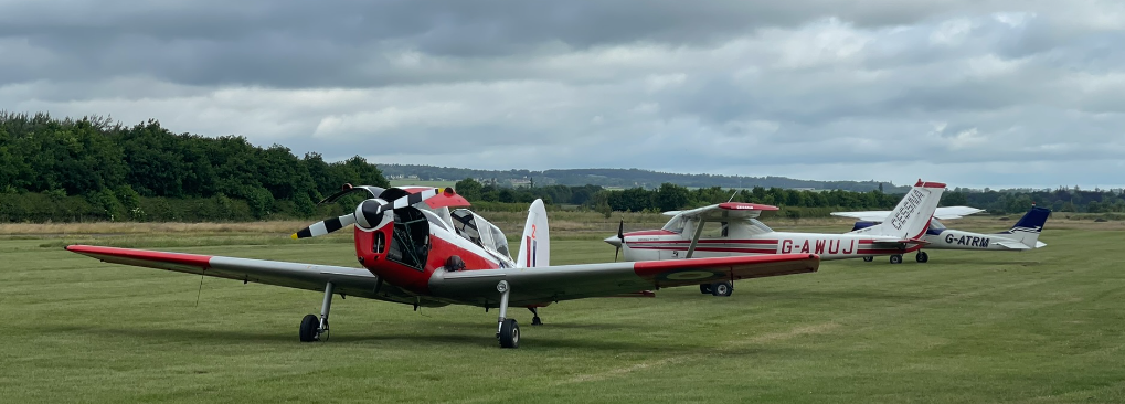
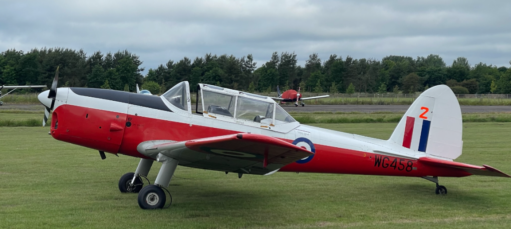
Today, the cloud bases were supposed to be above 4,000ft but when my instructor and I headed out to the aircraft – G-AWUJ, an F150H, a Cessna 150H built by Reims in France – it was clear they were a lot lower. After the lesson I checked the METAR from the nearest weather station and it was showing overcast at 1,800ft. However, during the lesson the cloud base was broken and afforded us some room for manoeuvring.
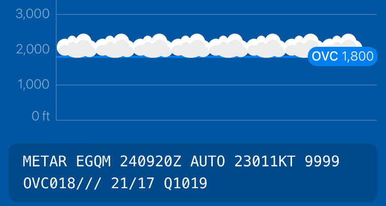
That text at the bottom of the image is the raw text of the METAR (meteorological aerodrome report). Let’s take this opportunity to go through what it means:
- EGQM – the International Civil Aviation Organisation (ICAO) code for the aerodrome or weather station. In this case, RAF Boulmer, on the Northumberland coast. Many licensed aerodromes around the world will have a 4-letter ICAO code that uniquely identifies them. They also may have a shorter International Air Transport Association (IATA) code which is 3 letters and you’ll often see this one printed on the labels the airport prints and sticks on your luggage handles at check-in.
New York John F Kennedy Airport is KJFK (ICAO) and JFK (IATA). Las Vegas airport is KLAS / LAS. All major airports in the contiguous 48 states (so, not Hawaii and Alaska) have an ICAO code prefixed witj a “K”. In northern Europe, most countries are prefixed with an E. London Heathrow is EGLL (ICAO) and LHR (IATA). Airports in Great Britain start with “EG”, airports on the island of Ireland start with EI, the Netherlands uses EH (Amsterdam is EHAM (ICAO) / AMS (IATA)), German airports start ED, etc. In Southern Europe airports tend to start with an L, Paris Charles de Gaulle airport is LFPG / CDG, Madrid is LEMD / MAD, Athens is LGAV / ATH, etc. - 240920Z – The first two numbers denote the day of the month (24th, of June in this case), the next four numbers are the time – in Coordinated Universal Time (UTC) – that the METAR was issued. Typically weather stations will update their METAR every hour or half hour. It is common for METARs to be updated on the 20th and/or 50th minute.
- AUTO – Signifies the METAR was automatically generated
- 23011KT – Means that the wind is coming from a heading of 230 degrees at a speed of 11 knots.
- 9999 – The visibility measured in metres. 9,999 is the highest value and effectively means “greater than 10km”.
- OVC018/// – means there is only one cloud layer and it is overcase at 1,800ft.
- 21/17 – means the temperature is 21 degrees Celsius, and the dewpoint (that is the temperature at which the moisture in that air condenses is 17 degrees).
- Q1019 – The QNH – pressure at sea level in hectopascals (hPa). For your altimeter to show your height above mean sea level (MSL) in the area of this weather station you would set the pressure setting to 1019.
International Standard Atmosphere (ISA)
Let’s take a quick detour to talk about a very important concept in aviation that directly impacts flight safety – the international standard atmosphere.
The ISA defines the standard atmosphere as 15 degrees Celsius and sea level pressure of 1013.2hPa (29.92 inches of mercury – Hg). The ISA is used to publish aircraft performance charts in the Pilot Operating Handbook. It is almost never a perfect match of the ISA so pilots need to calculate performance differences based on how different the pressure and temperature are on the day.
Today we had hot day – relative to the 15 degC standard, which means the air density would be lower than in the ISA, however, we also had higher pressure, which would have a counter-balancing effect on the density.
When I started the engine and set 197ft on the altimeter (the elevation above sea level of the highest point of the touchdown zone) the Kohlmann window where you see/set the pressure setting read 1018hPa. This means that if we skimmed across the sea at this setting, the altimeter would read 0ft – and you’d only experience 1013hPa of static pressure at 150ft above sea level (you lose 1hPa per 30ft of altitude).
Similarly, if you keep the same pressure setting and fly from warm air to cold air, you will actually have descended relative to mean sea level!
This shows just how important accurate altimetry is to safe flying.
The Plan (B)
I knew there were still gaps in my practical experience and knowledge and I mentioned this when I arrived. “I’m yet to do steep turns and soft field landings,” I said, although I was very keen to start doing navigation.
“And you’ve not done any PFLs yet?” asked the instructor.
PFLs are Practiced Forced Landings – simulating an engine stopping whilst at altitude.
I have done a few EFATOs – engine failure after take-off, which is dangerous but a straight-forward emergency to handle – but PFLs are a completely different kettle of badgers.
“No,” I said. And the instructor nodded and launched into a brief about PFLs.
There is a saying in aviation which clearly defines the priorities:
- Aviate
- Navigate
- Communicate
Failure to follow these priorities has led to fatal air crashes around the world. Some notable examples are:
- Eastern Airlines Flight 401 – The pilots became fixated on diagnosing a warning light that they hadn’t realised that the autopilot had become partially disabled and the aircraft descended into the Florida Everglades, killing 101 people. Although little solace for those affected, flight 401 was a watershed moment in civil aviation and the importance of aviating first became paramount, with training programmes and regulation changing as a result.
- Flash Airlines Flight 604 – Although disputed, it is likely that flight 604 crashed due to the Pilot Flying (PF), the Captain, becoming distracted by the autopilot mode changing resulting in loss of control of the aircraft and crash, with all on board lost.
So with these priorities in mind, you start by dealing with a PFL the same way as an EFATO – establish a safe glide speed – best glide speed in the C150 family is 60knots, or 70mph. In other words, FIRST YOU FLY THE PLANE.
Next is navigation, before you try to restart the engine look for a landing area and for any obstacles and hazards, such as electrical cables, pylons and wind farms. Unless you’re near a runway or prepared surface you could glide to, a field is often your best option.
Here is an example from one of my previous lessons. Here I select a field straight ahead (good), we can make it easily with plenty of flaps (good), the surface is recently harvested wheat (not great, not terrible), but as we get closer we see the field is full of bails of hay (dangerous). I’m fairly confident I could have landed in such a way that would have avoided those bails and we could have walked away, but hay bails have been added to my mental checklist to check for before selecting a landing area.
Selecting a landing area involves the evaluation of the following criteria:
Practice Forced Landing – Landing Area Checklist
- Surface wind – ideally we prefer to land into the wind to give us a slower ground speed on touch down
- Size – is it large enough to land and stop in safely?
- Slope – An uphill slope will slow you down faster after touch down
- Shape – Despite my assertion that a field “shaped like a runway” would be the best option, this is not correct as this means you can only land in one (or two) direction. A large, square or round field is actually best as it means that if you misjudge the power-off approach you can cut corners or extend your glide and land from a different direction.
- Surface – brown fields usually mean recently ploughed and are less suitable for landing on. Ideally you want a flat surface covered in short grass.
- Surrounds – Check for hazards and obstacles on the undershoot (before the landing area) and the overshoot (after the landing area) in case the landing doesn’t quite go to plan.
So that’s aviating and navigating done. Check! Last thing to do is communicate, if you’re already speaking to an air traffic service (ATS), send a mayday, explaining who you are, where you are and what your emergency is. If you’re not already speaking to an ATS station, switch to the emergency frequency 121.500 and set your transponder to 7700, which is general emergency. If you can explain where you expect to land then the emergency services will be dispatched to your location.
Briefing the PFL
During an EFATO your options are severely limited due to your altitude, but during a PFL you have the luxury of altitude and time to set up your landing properly, and also try to solve the problem that stopped the engine.
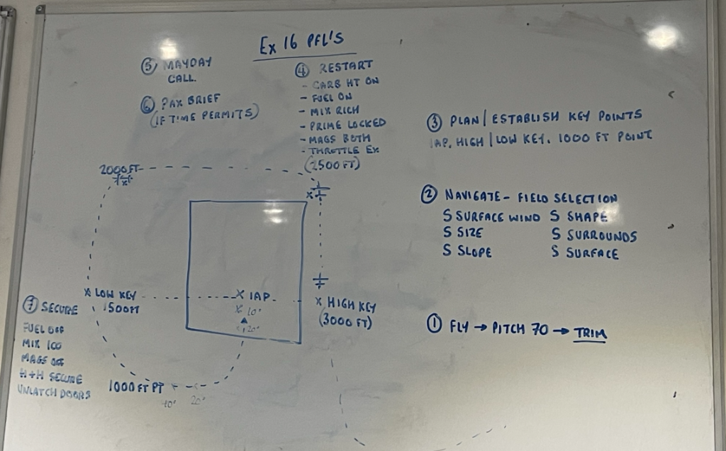
The ideal PFL landing involves flying a circuit around the landing area in a similar way as you would fly a circuit at an aerodrome but continuously descending and keeping the landing area in sight.
Once you’ve chosen your landing area, nominate an Initial Aiming Point (IAP) 1/3rd of the way into the field / surface. Why 1/3rd? It adds margin for error – you can always reduce this with flaps / slips.
At 3,000ft or above you start the PFL at the “high key point” (HK). This is an upwind point abeam the IAP.
At 2,500ft you turn onto your ‘crosswind’ leg of the circuit and run through checks to try and diagnose the issue. If this resembles the fire triangle then maybe you’re onto something!
- Fuel – Is there any fuel left in the tank / tanks? In aircraft with multiple tanks, is the fuel selector switch on the tank with fuel in it? Is there enough fuel getting into the engine – i.e. is the mixture rich enough? Is the primer in and locked? Is the throttle open? Try exercising the throttle control in case it has stuck.
- Air – is air getting into the engine? Check for carburettor icing by opening the carb heat valve.
- Ignition – is the magnetos switch on both? If not, the selected magnetos system (ignition) may have failed.
Easy as that. Let’s get into the air!
Take Off!
I pre-flight checked UJ, my instructor hopped in, and I taxiied up to the holding point to perform the pre-takeoff vital actions. With the flaps down, trim set for take off, instruments set, transponder on Mode C (transmitting squawk code + pressure altitude), I started to make a radio call then realised my error.
“Golf-Uniform-Juliet, ready for – Disregard!”
I had started to say we were lining up when I hadn’t even checked the approach path.
I turned in the holding point so I could see the approach path was clear and then tried again. “Golf-Uniform-Juliet, ready for departure, lining up runway 19.”
30 seconds later I was climbing over the golf course south of the airfield. “Golf-Uniform-Juliet, leaving the circuit to the east.” I turned and headed towards Coquet Island which sits just off the coast of Amble, and climbed to 3,500ft which was the plan briefed with my instructor before we took off.
“Can you get us a service from Newcastle radar please?” asked the instructor.
I nodded.
Basic Service
First I had to let the airfield I’d just taken off from know that I was changing frequencies. “Golf Uniform Juliet, changing frequency Newcastle Radar 124.380.”
We listened for a moment to Newcastle Radar. Newcastle (EGNT/NCL) is a busy leisure airport and it was starting to get busy with holidaymakers. At this time though we had missed the main morning rush and the frequency was quite quiet.
“Newcastle Radar, Golf-Alpha-Whisky-Uniform-Juliet, request basic service,” I said.
“Golf-Uniform-Juliet,” said the air traffic control officer (ATCO), “squawk 3750.”
I changed our transponder code and read back the instruction.
“Golf-Uniform-Juliet radar contact, are you going back to Eshott after?”
“Affirm, Eshott to Eshott.”
Usually, when asking for a basic service you have to provide a set list of information: callsign, type of aircraft, location, altitude/height/level, departure and destination airfields, intended routing, number of persons on board, flight rules, any other info, e.g. “Student PPL”), but this ATCO must see our flight school fleet doing general handling over the coast day in, day out, and was happy to get that confirmed.
“Golf Uniform Juliet, it’s a basic service.”
“Basic service, Golf-Uniform-Juliet,” I replied.
There are a few things that are mandatory to read back on the radio and reading back the TYPE of air traffic service is mandatory.
Practice Forced Landing
It was clear after take off just how low the cloud base was but there was a gap in the clouds which afforded us enough clear air to stay legal and try a PFL.
My instructor nominated a field first. It was reasonably rectangular and north-south even though the wind was from the west, which I thought was odd. By this point we were at 1,500ft so I aimed for the low key point.
“Where are you going?” asked my instructor.
I pointed at the field. “No, that one behind it,” he said, very calmly despite being flown around the sky by an idiot.
The field he had actually selected was, as you would expect, square, and with a good, clear approach path from the east into the westerly wind. I climbed back up to 1,500ft and tried it again. At the low key point I was a little high, which is better than being low, and turned onto a wide base leg. At around 800ft I lowered the flaps and it was obvious we would be able to land before the aiming point just fine.
Conscious of the 500ft rule (aircraft must not fly within 500ft of property, people or vehicles) and the sensitivity of some people to the noise of small aircraft, I broke off the approach and turned north while raising the flaps in stages.
“We’ll do some more of those next lesson but these clouds are going to be a problem for us today. Let’s do some steep turns instead.”
The Plan (C)
I flew over the coast off Seahouses – a lovely little fishing town I used to holiday to in my early childhood – and my instructor showed me the first steep turn – a 45 degree bank. This required a bit of additional power to keep the airspeed steady, and quite a bit of back pressure on the controls to keep the nose up.
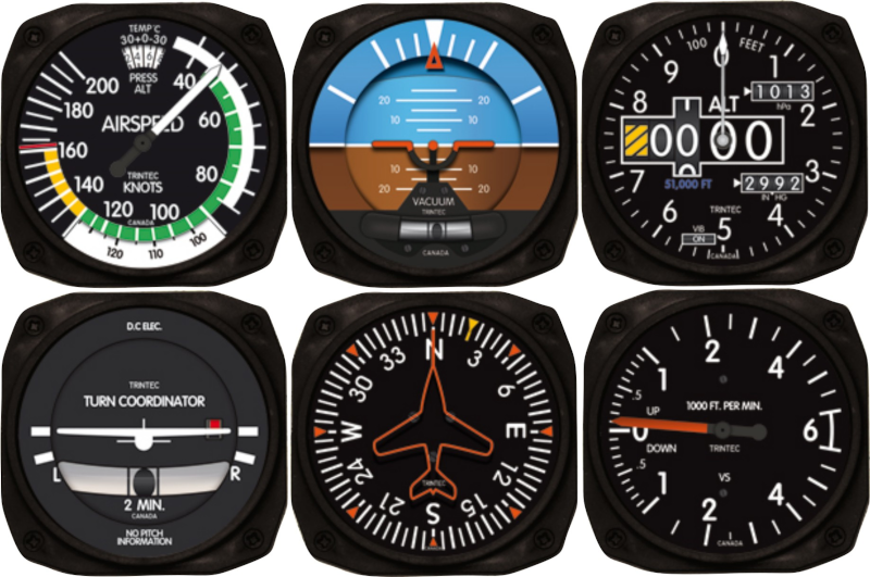
The Attitude Indicator – or “AI”, sometimes called the artificial horizon – is in the middle of the top row of a standard “six pack” of instruments. When you bank, the brown/blue part of the instrument remains aligned with the ground using a gyroscope. The white dashes around the outside of this instrument indicates degrees of bank. The two shorter lines nearest the big white (flying level) triangle at the top are for 10 degrees and 20 degrees of bank. So when you’re climbing away from a runway you generally limit your turns to 15 degrees of bank, i.e. keeping the orange needle between these two shorter lines. The first long white line is 30 degrees of bank is the usual limit for normal operations. The next long white lines represent 60 degrees of bank, so 45 is in between these two long lines.
I had been practising steep turns on X-Plane 12 for a few days and had been watching some great YouTubers such as Angle of Attack’s Chris Palmer describing the correct technique for @slicing the nose across the sky, so I think this helped and I did left and right steep turns at 45 degrees quite easily. Then came 60 degree steep turns:
60 degrees of bank turns require significant back pressure on the controls and full power to maintain altitude. Doing a 60 degree bank doubles the load factor on the wings, effectively meaning you are pulling 2G. Utility category aircraft like the C150 are certified to 4.4G so there was no risk of any structural issues at this G, but we were noticeably pressed down in our seats.
First I did a steep turn to the left, then to the right, trying to memorise the ‘sight picture’ for each turn – finding a spot on the engine cowling for where the horizon intersected it.
Finding these quite straight forward we decided to try something else and the instructor handed me THE HOOD.
The Plan (D)
I’ve flown wearing The Hood before. It blocks out your view of the outside world so you are reliant on flying using only the instruments.
I put it on and my instructor posed a challenge. “So, you’ve been caught on top of the clouds and you’re running out of fuel so you need to get down soon. What do you do?”
I knew this was more than just a hypothetical training scenario. There was a fatal crash in 2022 of a light aircraft which became stuck on top of the clouds. The Flying Reporter has a great video about the accident here.
I thought. “Speak to air traffic control and ask for help?”
“Exactly. What would you ask for?”
“Heading to a suitable airfield.”
“Exactly. We’ll ask for just that.”
While I was trying to maintain the heading and altitude he had assigned, he explained what I needed to ask for from Newcastle Radar, which was still very quiet, except for handling a KLM passenger flight departing for Amsterdam, but he had already switched to London Control.
“Golf-Uniform-Juliet. Request QDM, QDM, QDM.”
I’ve covered some of the Q codes before – principally the difference between QNH (pressure settings for altitude) and QFE (pressure settings for height above an airfield) but there are numerous others, and some relate to headings.
Q codes were developed between 1909 and 1913 when they became effective as an international standard for shipping but so many concepts and terms relate equally to aviation as to sailing (pitch, yaw, roll, rudders, pilots, abeam, port, starboard, inboard, outboard, etc) that the Q codes were useful for pilots too and became part of standard aviation language.
QDM is the magnetic heading one station needs to follow to reach the other. It assumes no wind or other drift so these will need to be added by the pilot trying to reach the other station.
“Golf-Uniform-Juliet, QDM is 186 degrees.”
“QDM 186 degrees, Golf-Uniform-Juliet.”
We estimated that the crosswind component caused by the westerly wind was about 20 knots at this altitude so we added 10 degrees to compensate for drift.
For the next 10-15 minutes I followed a heading of 196 degrees, quietly concentrating on the AI and doing regular scans of airspeed and altitude with an occasional glance at the vertical speed indicator and turn coordinator to verify what the other instruments were saying.
“Now take off the hood,”
I whipped it off and we were just approaching Amble. Amazing.
“OK, take us back to the airfield,” requested the instructor.
I pushed the transmit button on the controls and said, “Golf Uniform Juliet, request frequency change to Eshott 122.855.”
“Frequency change approved, squawk conspicuity, free call Eshott 122.855, good bye!”
“Squawk conspicuity, 122.855, thanks!”
Normally (according to the CAA’s Civil Aviation Publication #413 – famous or perhaps infamous amongst UK pilots) you don’t want to add lots of pleasantries and unnecessary chatter to clog up the frequency but as it was quiet I didn’t think a thank you would be out of order. To his credit, the gentleman on Radar that day had been very patient and slowed down his messages, knowing that we must have been doing a training flight.
Interception
Newcastle Radar knew we were heading home but Eshott didn’t, next job was to get in touch.
“Eshott radio, Golf Alpha Uniform Juliet, overhead Amble, joining overhead.”
This let anyone on Eshott’s frequency know where we were and that we were inbound, planning on a standard overhead join.
As we approached the airfield at join height (1,500ft above airfield level, QFE) I noticed a strange looking aircraft on the horizon. Was it a 737 coming in to land at Newcastle? No it looked closer than that.
“What’s that?” I asked.
My instructor said, “it’s the chippie.”
The RAF Chipmunk I’d seen earlier parked next to UJ was on a flight too.
Abruptly the Chippie turned towards us. We were to his right and therefore had right of way (“on the right, has the right”) and Air Law says he must turn right and pass behind us. Out of an abundance of caution I tilted my wings to make us more visible in case he’d not spotted us.
He flew towards us before breaking off in an extremely impressive barrel roll turning into an inverted dive.
Over the radio we heard, “you’ve been strafed, I’ll follow you in.”
Afterwards, still smiling about this interception by the 1950s RAF training aircraft, the pilot explained he wasn’t sure how far through my training I was but next time, if my instructor and I felt comfortable, he would join up and fly in formation.
I’m looking forward to sharing that video with you!
Glide Approach
My instructor wasn’t quite finished with me.
There was another aircraft in the circuit for runway 19 so I joined deadside descending to 1,000ft QFE (circuit height) while that other aircraft was downwind. I didn’t see the Chippie again until we were on the ground.
At 1,000ft, I turned to cross the threshold of runway 01 – the departure end of runway 19 – onto crosswind and then downwind.
“We’re going to have an engine failure on downwind, just do what we practised,” said my instructor.
Sure enough, the carb heat was set to hot and the engine RPMs dropped to idle.
I lifted the nose to attain 60 knots/70mph, and started to descend while trimming to maintain the descent rate, and tried to estimate when to turn onto base. Being a right-hand circuit, and flying a high winged aircraft, it was much harder to maintain visual contact with the runway while turning through base and onto final and I completely fluffed it up, lowering 10 degrees of flaps too soon and arriving low and slow.
“Go around,” sighed my instructor. He is a hard man to frustrate but I deserved that sigh, and more. What a muck up. In a real engine failure scenario we’d be in a field 100ft short of the runway undershoot with very red faces.
I pushed the throttle forward and closed the carb heat. Ahead of us was the aircraft also in the pattern, it was only just climbing over the trees at the upwind end of the runway. We were catching it fast.
The radio crackled, “Foxtrot Lima, going around.”
“Foxtrot Lima from Uniform Juliet,” said my instructor.
“Pass your message.”
“We’re right behind you and going to catch you up fast. Any chance you could extend your upwind leg and we can make an early turn onto downwind?”
“No problem we’ll extend upwind.”
I turned onto an early crosswind then onto downwind. Once stable at 1,000ft QFE my instructor simulated the engine failing again.
This time I turned a little too soon, we were high and I didn’t have any power to reduce to help me descend. It was very weird and I kept reaching for the throttle before remembering.
“We’re high,” I said.
“What are you going to do about it?” Asked my instructor.
I dropped 10 degrees of flaps, then 20. Paused, we still didn’t have enough descent rate. I dropped full flap – 40 degrees – and pushed the nose forward to maintain 60 knots. 40 degrees of flaps is verrrrrrry draggy and you need to nose-dive to maintain airspeed but I didn’t want to do that until I knew 20 degrees of flap wasn’t going to be enough – learning lessons from the first attempt.
I’ve done full flap landings before but never without power – in fact I was taught to have a little bit of power on to help avert a stall during the flare.
“Worth starting the flare early with no power and full flaps,” advised the instructor.
I tried, I really tried, but as soon as I added back pressure to the controls to start the flare the stall warning horn went crazy and I didn’t want to try and hold it off too much and risk a wing drop. The landing was…. firm. And bouncy. I think I may have landed on all 3 wheels too, which is not advisable. I’ve had a few firm landings and this was probably in the top 1 or 2 firmest landings so far. I think 30 degrees of flap might just have done it.
Some things to think about…
Here’s the track from today’s lesson:
It felt like a super long lesson but total time in the air was only 1 hour 05 minutes. Crazy!
More FPLs, maybe a soft field landing or two, then, maybe, just maybe, nav?
Watch this space.