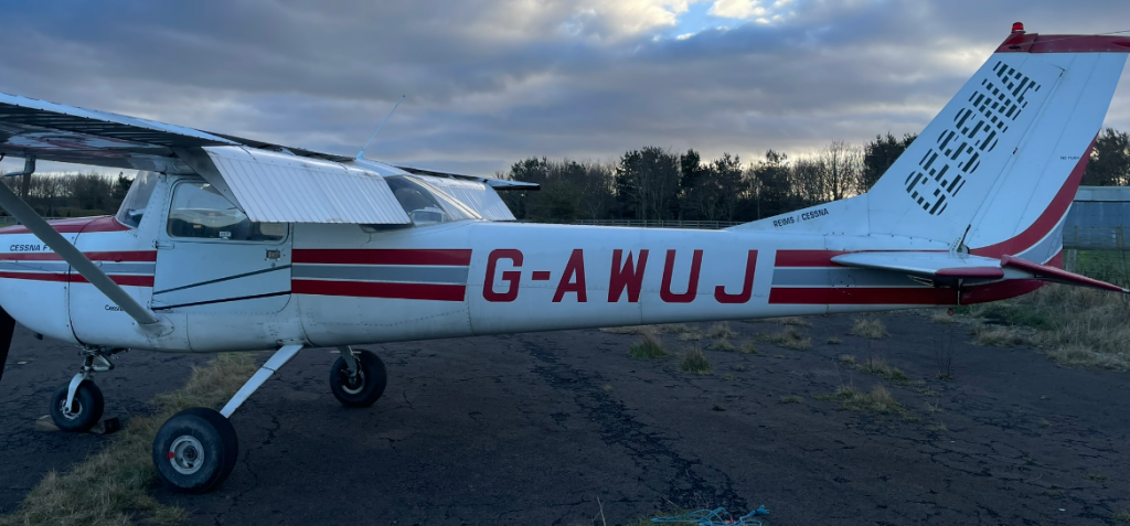
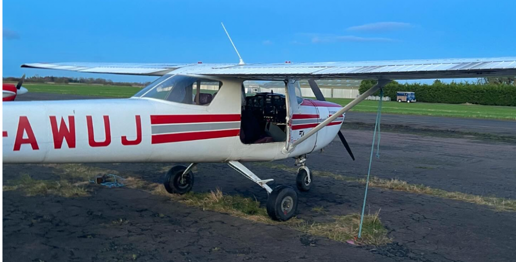
It’s been nearly 6 months since my last lesson, which saw me fly solo from my home airfield at Eshott, Northumberland to historic Berwick-upon-Tweed (which is still technically at war with Germany) and back without breaking the 1968 vintage Cessna under my control.
This lesson would be even better, more scenic and even more rewarding. Keep reading for a photog of Newcastle and Durham from the air at sunset!
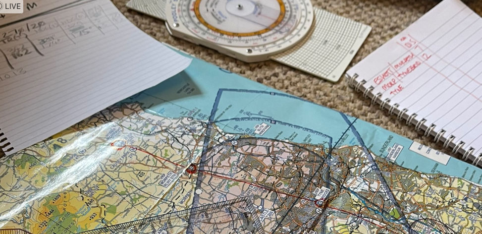
Flight Planning
Sunday arrived and it was the best weather the north east of England had seen in 2-3 months. Blue skies, occasional puffy white cloud and light winds.
I didn’t expect to fly my navigation lesson as it had been so long since I’d flown, but I planned for it anyway. My lesson was booked for 3pm but I started planning the flight at 11am, just after the Met Office had issued its F214 Spot Winds chart for the afternoon.
The F214 shows wind direction and speed, and temperature in celsius at various altitudes (height above mean sea level).
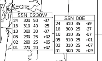
F214 Primer
- The left column shows altitude (1,000ft, 2,000ft ….. 24,000ft).
- The next column shows wind direction (where the wind is coming from) based on True North, e.g. 270 = 270 degrees, or West.
- The next column shows wind speed in nautical miles per hour (knots), e.g. 20 = 20knots (around 23mph).
- The final column shows air temperature, +07 = 7 degrees celsius. Air generally gets cooler by 2 degrees for every 1,000ft you climb, this is called the “adiabatic lapse rate” in aviation exams because reasons.
As the flight would take place between these two spot wind charts, I averaged them and calculated a wind vector of 295 degrees and a speed of 25 knots.
Next, I plotted my route on the VFR aviation chart (map) with a route that took me from the airfield south to the nearest Visual Reporting Point – VRP – which is Morpeth Railway Station.
VRPs are clearly-visible landmarks you can use to navigate just with your eyes and a map
This VRP also defines an entry point into the controlled airspace of Newcastle International Airport 6 miles to the south.
From Morpeth, once cleared by Newcastle air traffic control (ATC), I’d fly to the Tyne Bridges VRP, which is approximately the exit point of the airspace when below 3,000ft (airspaces are 3-dimensional just for fun and to melt your brain while trying to operate heavy machinery).
From the Bridges VRP I’d fly direct to Durham City, which is also a VRP because it has a beautiful cathedral which stands out from the rest of the city, as I was about to find out!
My route back to the airfield was the reverse, as you’d expect.
My 5th Instructor
My usual instructor (who flies long haul Airbuses) was stuck in the Caribbean due to a fault with the aircraft he was supposed to bring home, soothing his troubles with rum, so his stand-in arrived (90 minutes late due to an incident at another airfield with another aircraft that held his previous lesson up), shook my hand and said, “show me what you’ve got!”
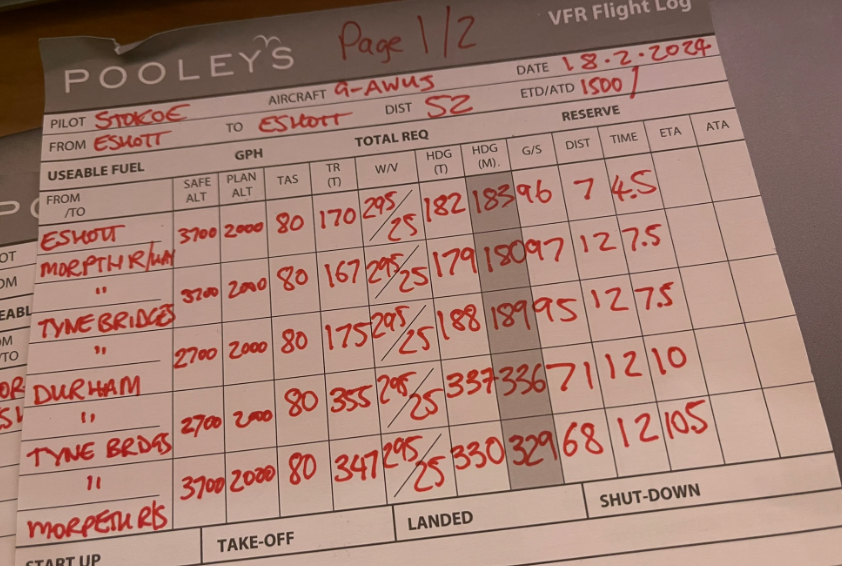
I unfurled my maps, charts, F214 and Plog – pilot navigation log. This was already filled in including calculated magnetic headings that accounted for drift due to the 25 knot winds at 2,000ft – my selected altitude for this nav.
I reeled off my plan, briefed the departure route, explained the VRPs and what I expected to see at the half-way points between VRPs, I described the timings and what I would do if Newcastle ATC didn’t allow me straight into their air space. He was happy with all of that, so we headed out to the aircraft.
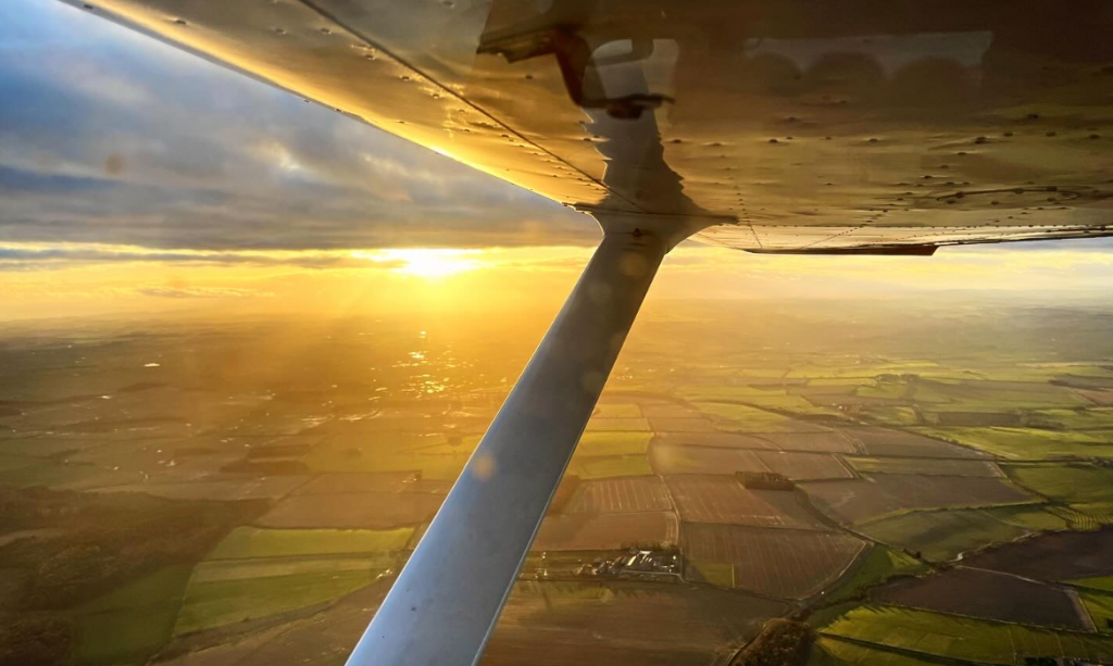
With the aircraft checked, I started the engine, radio’d my intentions and taxiied to a holding point two runways away. Shortly after, I took note of the time and seconds later lifted off the tarmac, sailing into the slowly setting sun. It was 4:30pm, the sky was golden orange and the air was smooth, despite the 25kt wind awaiting us at 2,000ft.
I departed the circuit on the downwind leg with a radio call, started my timer, performed a FREDA check and turned onto my first heading – 183 degrees, almost due south. This would see us arriving overhead Morpeth VRP in 4.5 minutes.
I radio’d the airfield saying I was switching frequencies to Newcastle (this is a safety thing, so they know your intentions and how to contact you) but there was no traffic on frequency. I flip-flopped the radio to 124.380 and paused to check if the frequency was clear.
It wasn’t.
My ears were assaulted by transmissions between ATC and British Airways (“speedbird”), KLM and Lufthansa jets all arriving into or departing from Newcastle.
When there was a gap I quickly transmitted… “Golf-Alpha-Whisky-Uniform-Juliet request basic service and zone transit.”
I didn’t get a response as ATC continued to guide the metal tubes full of passengers safely to their destination.
After a few moments, we were approaching Morpeth Railway Station without a clearance so we could not continue. I started a slow right-hand “orbit” (circle) overhead the railway station.
“Golf-Uniform-Juliet pass your message,” said ATC.
I reeled off the standard phraseology for a basic service and zone transit, this is effectively filing a flight plan whilst in the air. “G-UJ, Cessna 150, Eshott to Eshott, Request routing Morpeth, Tyne Bridges, Durham then the reverse, 2 POB (persons on board), VFR (visual flight rules – meaning I was primarily flying using visual references so needed to stay clear of cloud), request basic service and zone transit.”
“G-UJ, squawk 3761, remain outside controlled airspace.”
Clearances and lack of clearances must be read back, “remain outside controlled airspace 3761, G-UJ,” I replied, continuing my orbiting.
Finally, I was cleared into the controlled airspace, made a note of the time, turned onto my heading and made my way towards the Tyne Bridges.
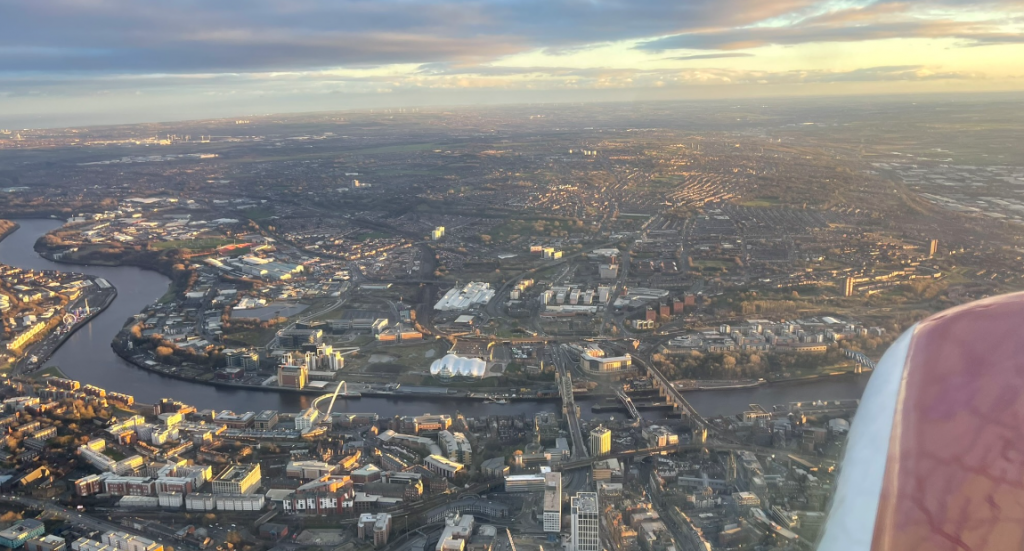
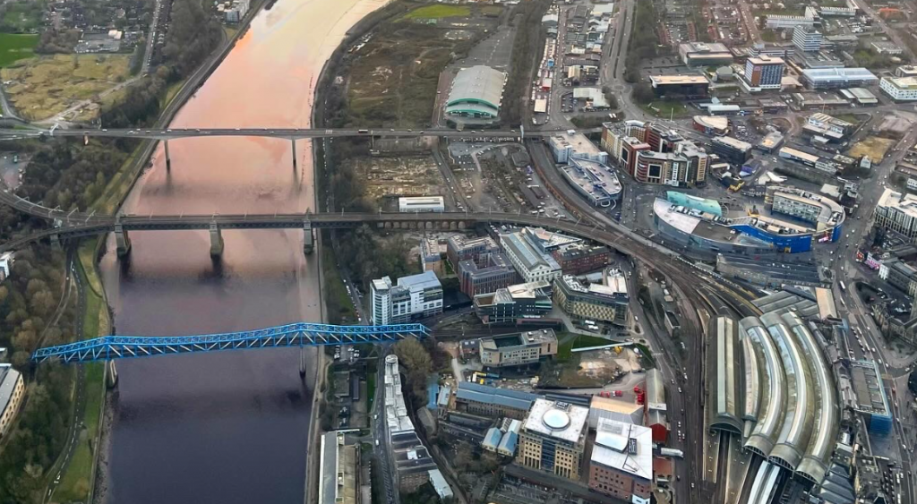
Newcastle’s Quayside is famous for its bridges. The Tyne Bridge is a miniature Sydney Harbour Bridge (although was built first!), the High Level Bridge was the world’s first double-decker road/rail bridge, and the Millennium Bridge, also known as the Millennium Eye, is the world’s first tilting bridge.
In the setting sun the Quayside and the bridges glowed orange, its was stunning.
At the Bridges, I turned onto a heading of 189 degrees and marked the time in my plog. After a few moments we picked up the A1, the main road between London and Edinburgh which ran through Gateshead and Newcastle (the cities either side of the River Tyne).
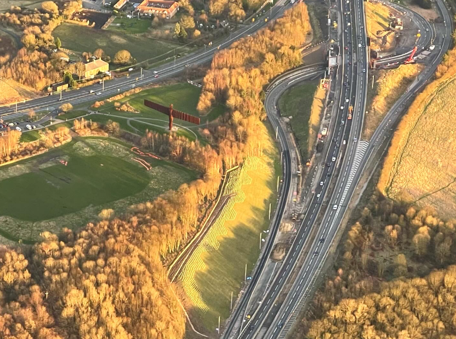
Along the A1 we could clearly make out the Angel of the North, a 66ft tall rust-coloured angel designed by Anthony Gormley with a wingspan of 177ft (larger than a Boeing 757 and a lot larger than a Cessna 150).
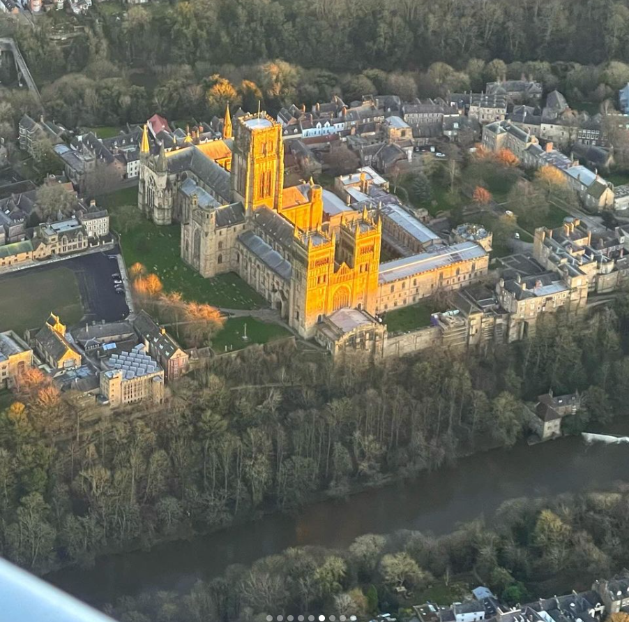
A couple of minutes later we could make out Durham in the distance, it was the second large conurbation we could see after historic Chester-Le-Street, home to Lumley Castle and a Saturday morning Parkrun along the riverside!
Durham was also aglow, with the large blocky cathedral shining in the sun.
After a few minutes we arrived overhead, bang on my estimated arrival time I hasten to add, my instructor took the controls for a moment while I took some snaps.
Time was pressing on – the sun was due to set at 17:17 and the Rules of the Air say that visual pilots without a night rating had to land within 30 minutes after sunset. (Thankfully, my new instructor is a 737 pilot and is allowed to fly at night).
I turned around and flew back towards the Bridges, this time into a headwind.
The trip back was noticeably slower going, but Newcastle gave us immediate clearance back into their now-quiet airspace.
I flew over the city centre again, keeping an eye on the large grassy “Town Moor” which was our emergency landing area should the engine quit on us, and continued north past Newcastle Airport, with its runway lights turned on.
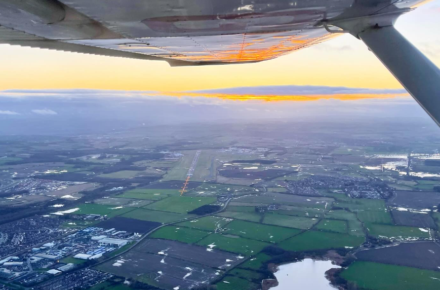
We stayed outside of the ATZ – Aerodrome Traffic Zone – to avoid another radio frequency change to the Tower controller – and continued our long slow slog northbound.
Shortly after passing Newcastle Airport, Newcastle Radar ATC notified us of traffic ahead, a helicopter flying at 1,700ft. I maintained 2,000ft altitude just in case as we couldn’t see it at first.
Eventually the helicopter’s landing light appeared in the distance and we cruised through the silky smooth air and watched the little whirlybird slide past us.
I got to Morpeth Railway Station VRP a couple of minutes late as – we think – the wind has started to gain speed. I turned onto my final heading for Eshott.
My First Approach In 6 Months
A couple of miles out, I switched radio frequency (with Newcastle ATC’s permission) to the airfield Air/Ground frequency and announced our imminent arrival. A couple of miles out, I spotted the windsock was showing the wind direction hadn’t changed since our departure and I steered the Cessna to left-base for runway 25. The sun was already below the horizon so the runway was darker than usual (it is an unlit airfield) but clearly visible in the twilight. I have pretty good night vision anyway.
I slowed to flap operation speed, lowered 20 degrees of flaps and turned onto final with a radio call. I remained high as there was still a 15-20mph head wind down the runway, so I had to travel through more air than I normally would to arrive at the runway.
The descent towards the runway was quite clean, I maintained heading with the rudder pedals and dabs of aileron, and kept on my 60knots approach speed with pitch control (elevators) whilst controlling the descent rate with the throttle. As we came over the threshold of the runway, I pulled out the throttle and started to raise the nose.
With a gentle bump and a “shush” from the tyres on the tarmac, I made a pretty good landing considering it had been so long.
We parked up and tied down the trusty aircraft that had just taken us on a visually stunning tour of the North East.
“That was spot on. You can do that yourself next time,” said the instructor.