The night before this lesson I checked the weather. It said the skies would be clear but the wind would be 13 knots (~15mph) gusting to 22 knots (~25.5mph) from a heading of 250 degrees (i.e. from the west-ish).
When I arrived at the airfield the wind had picked up considerably and there was a large wall of dark cloud to the west of the airfield, coming closer and closer. It had everyone peering out of the clubhouse window trying to figure out what it would do.
“Go and check over the aircraft then come back for the briefing,” directed my instructor.
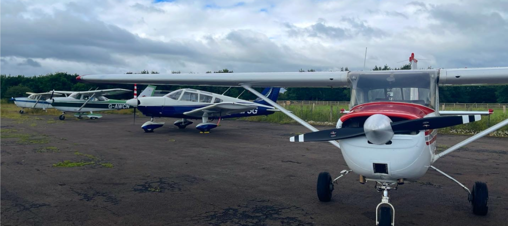
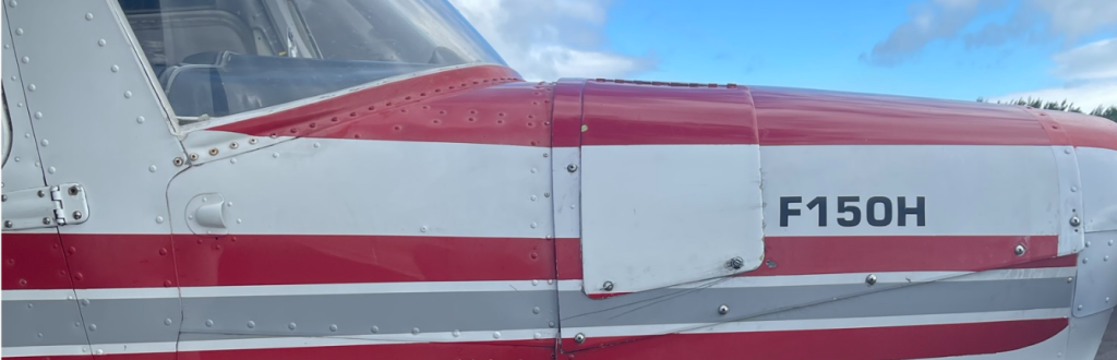
I went out to the Cessna F150H I expect I’ll be flying throughout the rest of my training – G-AWUJ, known as UJ, Yoo-Jay, in the flight school – and performed the internal and external checks. I also set up my GoPro on the front windscreen. She was in perfectly serviceable shape so I returned to the clubhouse.
It was looking like the Cheviot hills was causing the large cloud mass to break apart so we were happy to go flying, but what were we doing today?
I’d ran through several practice-forced-landings (PFLs) on X-Plane 12 the night before, with a 30 knot westerly wind and found it near impossible to fly upwind any meaningful distance during the idle-power descent. Glide approaches from downwind were proving impossible, with me repeatedly landing short of the runway if I hesitated for longer than a second. I knew I’d struggle if we did any of those today.
“Let’s plan a nav,” said my instructor.
A giant smile crossed my face.
Things just got real.
Air Navigation Planning Considerations
Today we would fly between Eshott Airfield in Northumberland, England and the historic town of Berwick-upon-Tweed 62 nautical miles up the coast.
Incidentally, the town of Berwick was technically still at war with Russia for 60 years after the Crimean conflict ended due to being named on the original declaration but being omitted from the declaration of peace.
There’s a saying in aviation.
When the weight of the paperwork equals the weight of the aircraft only then can we go flying.
Pilots
Flight planning is a complicated and lengthy process, but it needs to be.
When you drive your car down the road you’re in full control of your speed and path across the ground, but in an aircraft that’s not the case. Wind will blow you off course and alter your ground speed inconsistently throughout the flight.
There are many factors to performing an accurate and safe flight, including:
- wind direction and strength
- minimum safe altitudes (i.e. avoiding high ground and obstacles such as wind turbines, smoke stacks or power lines)
- local magnetic variation (we learn to navigate using only the magnetic compass as our primary directional source – although this is augmented with a gyroscopic directional indicator which is more stable in turbulence and turns)
- ground speed
- indicated airspeed, true airspeed and calibrated airspeed
- desired ground track
- fuel endurance and regulatory minima/contingencies
Planning the route
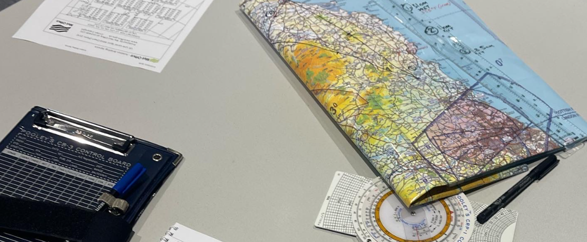
For a simple short navigation like this one, the first thing we do is draw a line on one of the official maps between our point of departure and destination. In this case we used a 250,000:1 Pooleys VFR chart and drew a line between Eshott and Berwick. I measured the line using a special ruler and found the distance to be 31 nautical miles (nm) each way, or 62nm overall.
We plan our route on a pilots log, or “plog”, and I entered the origin, destination and distance at the top of the plog.
Next, using an aviation protractor (like a normal protractor but 10x the cost) I found that the direction along the ground (called the “track“) was 342 degrees. Almost due north but a little to the left.
However, on a day like today with a strong wind, if we pointed the nose at 342deg we’d end up being blown wildly off course and instead of arriving at the coastal town of Berwick, we’d end up somewhere over the North Sea. So we needed to establish the direction and strength of the wind (called the “wind vector” or w/v), and that’s where we turn to our friends at the Met Office. The UK’s Met Office, based in Exeter, south-west England, provides an Aviation Briefing Service, which includes current and forecast winds and air temperatures at various altitudes. The Aviation Briefing Service also provides significant weather reports and other invaluable charts. This is free for non-commercial pilots including students such as myself, and even for commercial pilots it’s a very reasonable £57.60p per year, at the time of writing. in the aviation world where everything is costly, this is a bargain.
The Met Office publishes Form F215, which is the chart for “Significant Weather (Low Level) and Spot Winds”. The spot winds is particularly helpful for navigational planning as it allows you to see the wind vectors along your path of travel.
The flight today would take place between two wind forecasts, one to our west showing a wind vector of 30 knots from 280 degrees, and one to our west showing 30 knots from 270 degrees. If your gut is telling you to average them then it would be correct. So our expected wind vector for the flight was 30 knots from 275 degrees. Sometimes written as 275/30 or 275@30. On a METAR, this would be seen as 27530KT.
So how do we work our which direction to point our nose? Let me blow up your brain by saying this: if you fly faster you don’t get blown off course as much, so the amount of “wind drift” to compensate for depends on your true airspeed (TAS)!
So today we’d need to work it out based on our planned TAS of 80 knots (~92mph).
Calculating your drift is relatively straightforward trigonometry but most pilots use a “flight computer”, a mechanical fancy slide rule device that makes all aviation calculations a case of simply spinning a wheel.
I use the Pooleys CRP-1:
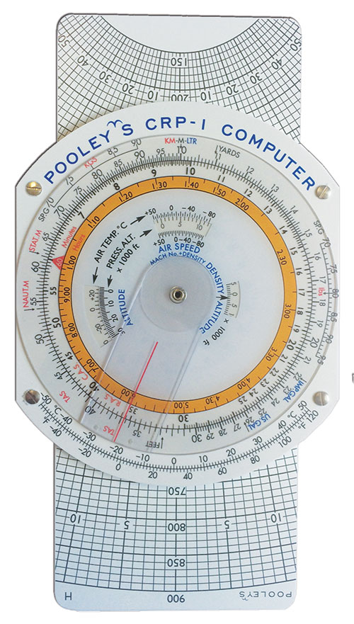
Despite looking extremely complex, it has only a few moving parts and makes conversions simple and calculations, for example, nautical miles travelled in a given time based on TAS is just a wheel spin away.
The CRP-1 is double sided, with a wind calculation side (not shown above) and a units conversion side (above). Using a technique called “wind down” we set our TAS to 80 knots (kt) and spun the dial to show a heading of 275 degrees (the wind direction), and put a dot 30kt down from our TAS, on the centre of the 50kt line. Next I turned the dial to the true heading of our track of 342 degrees. The dot I had drawn on the centre of the 50kt line had moved to the right by 21 degrees, which gave us our next value. I turned the direction dial to put the heading of 342 under the 21 degrees of drift line and it balanced the drift at 20 degrees. So we should expect to turn our nose 20 degrees into the wind to maintain our track on the way to Berwick (322 degrees).
But wait, there’s more!
That’s the TRUE track, not the magnetic track which our compass will read! We referred back to the map which showed the magnetic lines across the north of England and the borders with Scotland. Our path lay between two such lines called “isogonals”. Off to our west was a line of magnetic variation showing 0.5 degrees to the west, and one to our east showing 1.5 degrees of variation to the west. Averaging them out gave us 1 degree of magnetic variation, which we added to our planned heading.
But we weren’t done yet! <groan>
Aircraft are made up from metal and have lots of electronics in them which can interfere with magnetic compasses, so each aircraft has its own magnetic deviation card in the cockpit which shows the over or under reading at every 30 degrees.
We finally landed on 325 degrees heading for this first leg.
But that was only half the story, we would have a completely different wind vector on the return journey so we calculated that too. The return leg would require a heading of 183 degrees.
Planning the speed, fuel and altitude
The CRP-1 also told us we’d have a 16 knot headwind component on the way up to Berwick so we expected a ground speed of 64kt or 73mph. Not the fastest vehicle in the world, but with a direct path it would still outpace any (legally driven) car. On the way back, with a slight tailwind we expected 86kt, which is more or less 100mph across the ground.
So I knew which direction to fly and how fast, but not how high. We looked again at the map and found all the highest points along our route, then rounded up to the nearest 1,000ft and added 1,000ft for safety. The Cheviot hills off to our west are the highest points for miles around and gave us a minimum safety altitude of 3,700ft. However, as today offered tens of miles of visibility we planned to fly the route at 2,000ft and would only climb to the safety altitude if we encountered low visibility conditions (such as a cloud bank).
Finally, we planned the fuel. Per the Pilot Operating Handbook (POH), the F150H has capacity for 22.5 US gallons of fuel and the aircraft was fully fuelled that morning. This equates to 85 litres of fuel in those wing tanks.
For today’s flight, we calculated the leg north to Berwick would take 28.5 minutes and the return leg, with the tailwind, would only take 21.5 minutes, a planned flight time of 50 minutes. We rounded up to an hour for simplicity and safety. Our F150H burns 20 litres per hour at 80kts, we added 2 litres for start and taxi, 7 litres to allow us to divert to nearby Newcastle Airport in the event that Eshott closed, we added 45 minutes of hold time – 15 litres. A grand total of 42 litres, well within our required fuel endurance, and we only really expected to use under 20 litres of that.
Take Off!
Let’s get to it! So we jumped in the aircraft and found that my GoPro had been swiped, we later found it in the briefing room, someone saw it while we were planning and thought it had been left! So I’m afraid there is no video of this flight
After starting and starting the taxi to runway 25 (straight into that high wind, which is good) another flight instructor came on the radio saying to expect “a lot of turbulence on take off, but it gets smoother above 1,000ft.”
I did all the checks, pulled onto the runway and pushed the throttle forward. The airspeed needle moved almost immediately and I barely had enough time to check the temperatures and pressures and stability of the RPMs before we were at 60 knots of airspeed and I climbed away from the asphalt
The other FI wasn’t joking and we immediately got hit by waves of air, lifting the nose, then releasing it. As we climbed above the trees surrounding the airfield we hit windshear and the left wing dropped about 20 degrees in an instant, I had to apply almost full opposite aileron to get it back to level. My FI who is mega-chilled just stared out the window.
(It’s not discussed, but I wonder if the flight instructor course is mostly about training how to adopt an ultra-calm, super trusting, slow and methodical persona. Leaving student pilots to make mistakes and only intervene if something is truly imminently grave is a serious skill set).
With the airspeed indicator rapidly oscillating between 60 knots and 75 knots I raised the flaps, checked under the high wing for traffic and turned onto the crosswind leg, keeping the Cessna’s nose pointing into the wind to try and follow the pattern and make right-angle turns.
I’ve been doing A LOT of reading and watching videos about the PPL course lately and it has fully dawned on me that the course is ultimately preparing you to become Pilot in Command (PIC) with passengers on board and I’ve started to adopt the PIC mindset when flying. I told the instructor I was going to extend the crosswind leg because it would allow us to climb to 2,000ft by the time we turned into the overhead so we could start the nav at the correct altitude.
“Very good,” he said, and left me to it.
I turned downwind at about 1,700ft (above mean sea level, or QNH) then, due to the instant massive tailwind, turned north to overfly the airfield in “the overhead”. The “overhead” is exactly what it sounds like – the bit above the airfield, but it has a special meaning as aircraft arriving at the airfield will enter the overhead at a published height above the ground (1,500ft above airfield level, or QFE). So we both were looking out for threats out of the windows. Above the airfield I followed the procedure or: Turn, Time, Talk, Task.
- Turn – starting the nav, I turned onto a heading of 325 degrees and ensured I was at 80 knots airspeed and trimmed to maintain 2,000ft.
- Time – I took a note of the clock on the dashboard – almost exactly 9:10:00 zulu (UTC) – 10:10am local time. And our half way point was just 15 minutes away!
- Talk – Let everyone know what’s going on. “Golf-Uniform-Juliet,” I said over the radio, “leaving the circuit to the north.”
- Task – I ran through the FREDA check – fuel, radios, engine, directional indicator, altitude, all was good.
And then the juggling began. The wind from the left kept pushing the tail fin causing us to steer left, the turbulence was better at 2,000ft than at 1,000ft but it was still a little choppy. And the airspeed kept varying by +/- 5 knots.
En route
Shortly after departing the airspace around the airfield I reported that I was changing frequency and called Newcastle Radar with whom I arranged a Basic Service. I’ve previously got a service from Scottish Information however Newcastle participates in a network which makes up the Lower Airspace Radar Service (LARS) and provides better coverage. A Basic Service is a simple overwatch and information service, it permits the pilot to do pretty much whatever he or she wants, but the air traffic controller will keep them informed of regional pressure changes (which happened on this nav, as the QNH dropped from 999hPa to 998hPa) and any reported traffic.
I’m always impressed by how courteous and friendly Air Traffic Control Officers (ATCO) are. It’s really cool talking and listening on the same frequency as British Airways, KLM, Jet2, Ryanair and others, but they treat those of us in the little planes just as well as they do the big tin. Although I was terrified at first, I’ve no concerns these days of talking on the radio. Experience does help though!
At the half way point I identified that we were 5 degrees off course. We should have flown directly over a small hill but it was to our right. So I turned 10 degrees to the right and planned to fly this new heading for the same amount of time we’d been going off-track.
Eventually, the coastal town of Berwick came into view and without changing heading we tracked straight to it, much to the pleasure of trigonometrists worldwide.
Like I said, I didn’t have the GoPro but I did take some photos as my instructor kindly took the controls for a few minutes as we circled over the town.
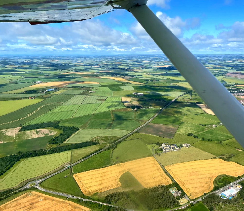
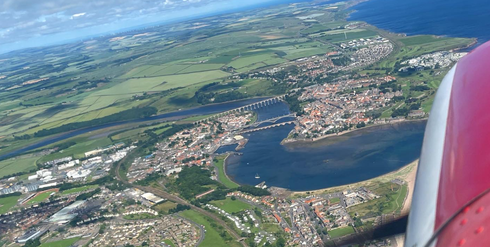
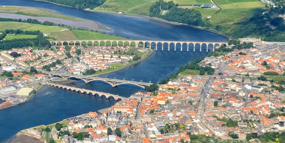
It was a very special view.
And then it was time to head back. I turned (183deg), timed (calculated 21 minutes for the return leg which equated to arriving at 10:07z), didn’t need to talk, but I did my task: FREDA check.
For some reason, possibly a change in the strength of the wind, we immediately started to drift left of the track we had just followed and had to correct after a minute or two. This involved a 6 degree right turn into the wind to compensate, for 2 minutes, then 3 degrees left to continue on course.
Eventually, we flew over the small hill, past the golf ball radar station that sits overlooking Alnwick watching out over the North Sea for baddies, and I requested a frequency change back to Eshott from the chap on Newcastle Radar.
Overhead Join and a Bumpy Approach
“Golf-Alpha-Whisky-Uniform-Juliet, 2 miles west of Alnwick, 2000ft, inbound to join overhead.”
I followed the A1 south and flew overhead the airfield, looking for the windsock. It was still pointing towards 70 degrees (indicating a wind from 250) and was fully erect, indicating a robust wind.
I had a feeling this landing might take a few goes.
As the pattern for runway 25 is a left-hand circuits (you make left turns, keeping the runway on your left), I turned left out of the overhead and began to descent north of the runway (on the “deadside”).
“Golf-Uniform-Juliet, descending deadside, runway 25.”
The wind was very strong and we didn’t cover much ground as we descending directly into the wind – I said to the instructor that i would stay high on the approach. I turned onto crosswind at 1,000ft and then onto downwind, with the mandatory radio call, followed by the BUMFILCH checks (brakes, undercarriage, mixture, fuel and flaps, landing light, carb heat, hatches and harnesses). I turned quickly onto base leg knowing that tail wind would take us far away from the airfield quickly. I pointed the nose of the aircraft practically at the runway threshold to maintain a decent base leg, and only started to configure for landing as I turned onto final.
The runway was less than a mile away but with a strong head wind we’d have to travel through a lot more than a mile’s worth of air as we descended. So I stayed high, dropped flaps to 20 degrees and carried out an approach that would have felt familiar to a Harrier jump jet pilot landing on a ship. It felt like the ground came up to meet us almost vertically.
It wasn’t the prettiest approach, I had to fight in all three axes to keep even remotely on-profile, and I was spring-loaded to go-around all the way down.
At about 50ft, I cleared an obstacle just prior to the runway threshold and could see the runway numbers coming up to meet us. A gust of wind blew us to the right but I caught it just in time and with a slight left bank the left tyre rolled onto the ground, followed by the right, then I lowered the nose wheel to the ground.
All things considered, it was a good, gentle landing.
Next Time….
After parking and shutting down the aircraft we went inside to debrief, which was (no pun intended) brief.
My instructor bought a round of coffee and said next lesson I’d do the same trip again but solo.
I’ll make sure the GoPro comes along next time.
Here’s our track as recorded by Flightaware ADSB feeders: